Drone Mapping and Surveying Techniques
Drone Mapping and Surveying Techniques:
Drone Mapping and Surveying Techniques:
Drone mapping and surveying techniques have revolutionized the way data is collected for various industries, including the oil and gas sector. Drones, or unmanned aerial vehicles (UAVs), equipped with high-resolution cameras and sensors, can capture detailed images and data from the air, providing valuable insights for planning, monitoring, and decision-making processes. In this course, we will explore the key terms and vocabulary related to drone mapping and surveying techniques in the oil and gas industry.
1. Drone: An unmanned aerial vehicle (UAV) or drone is a flying machine that can be controlled remotely or autonomously. Drones used for mapping and surveying purposes are equipped with cameras, sensors, and GPS technology to capture data from the air.
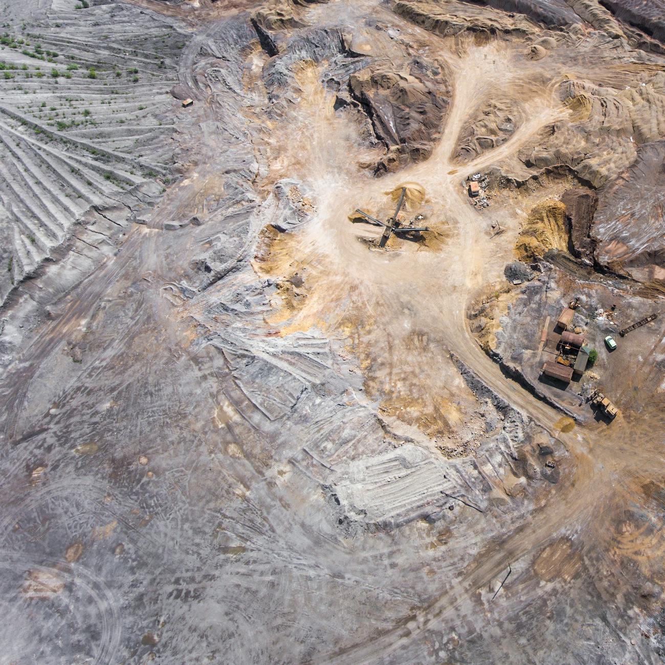
2. Mapping: Mapping refers to the process of creating a visual representation of an area, typically using aerial imagery or satellite data. Drone mapping involves capturing high-resolution images of the landscape from the air and stitching them together to create detailed maps.
3. Surveying: Surveying is the practice of measuring and mapping the Earth's surface to determine the positions of points, distances, and angles between them. Drone surveying uses UAVs to collect data for creating maps, models, and 3D reconstructions of the terrain.
4. Photogrammetry: Photogrammetry is the science of making measurements from photographs. In drone mapping, photogrammetry is used to extract 3D information from 2D images captured by drones. By analyzing the images and identifying common points, photogrammetry software can create accurate 3D models of the terrain.
5. Orthomosaic: An orthomosaic is a high-resolution, georeferenced image created by stitching together multiple aerial images captured by a drone. Orthomosaics are used in drone mapping to create accurate maps of the terrain without distortion caused by perspective or terrain elevation.
6. Digital Elevation Model (DEM): A Digital Elevation Model (DEM) is a 3D representation of the Earth's surface that shows the elevation of terrain features. DEMs are created using elevation data collected by drones and are used for various applications, such as flood modeling, slope analysis, and land development planning.
7. Point Cloud: A point cloud is a collection of data points in a 3D coordinate system representing the external surface of an object or terrain. Drones capture point clouds using LiDAR (Light Detection and Ranging) sensors or photogrammetry techniques to create detailed 3D models of the terrain.
8. LiDAR (Light Detection and Ranging): LiDAR is a remote sensing technology that uses laser pulses to measure distances to the Earth's surface. Drones equipped with LiDAR sensors can capture accurate elevation data and create high-resolution 3D models of the terrain, even in challenging environmental conditions.
9. Thermal Imaging: Thermal imaging is a technique used in drone surveys to capture heat signatures from the Earth's surface. Drones equipped with thermal cameras can detect temperature differences in the terrain, which is valuable for applications such as detecting pipeline leaks, monitoring wildlife, and assessing vegetation health.
10. Multispectral Imaging: Multispectral imaging involves capturing images in multiple wavelengths of light beyond the visible spectrum. Drones equipped with multispectral cameras can analyze the health of crops, monitor soil moisture levels, and identify vegetation stress in oil and gas fields.
11. Global Navigation Satellite System (GNSS): GNSS is a satellite-based navigation system that provides global coverage for precise positioning and timing information. Drones use GNSS technology, such as GPS (Global Positioning System), to navigate, collect accurate geospatial data, and ensure the safety of flight operations.
12. Ground Control Points (GCPs): Ground Control Points (GCPs) are known reference points on the Earth's surface used to georeference aerial images captured by drones. By placing GCPs in the field and collecting their coordinates with GNSS equipment, drone mapping accuracy can be improved through the correction of image distortions and errors.
13. Data Processing: Data processing involves the analysis and interpretation of the raw data collected by drones during mapping and surveying missions. Specialized software tools are used to process drone imagery, create 3D models, generate maps, and extract valuable insights for decision-making in the oil and gas industry.
14. Remote Sensing: Remote sensing is the science of collecting and interpreting information about the Earth's surface without direct physical contact. Drones equipped with remote sensing technologies, such as cameras, LiDAR, and multispectral sensors, can capture valuable data for monitoring environmental changes, infrastructure inspections, and resource management in the oil and gas sector.
15. Data Accuracy: Data accuracy is a critical aspect of drone mapping and surveying techniques in the oil and gas industry. Accurate data collection, processing, and analysis are essential for making informed decisions, monitoring assets, and ensuring safety and compliance with regulatory requirements.
16. Data Resolution: Data resolution refers to the level of detail captured by drones during mapping and surveying operations. Higher resolution data provides more precise information about terrain features, infrastructure assets, and environmental conditions, enabling better analysis, planning, and management in the oil and gas sector.
17. Data Integration: Data integration involves combining and analyzing multiple datasets collected by drones, sensors, and other sources to create comprehensive maps, models, and reports. Integrated data sets provide a holistic view of oil and gas operations, improve decision-making processes, and optimize asset management strategies.
18. Environmental Monitoring: Environmental monitoring using drones involves collecting data on air quality, water resources, vegetation health, and wildlife habitats in oil and gas exploration and production areas. Drones equipped with sensors and cameras can provide real-time environmental data for assessing and mitigating potential impacts on ecosystems and biodiversity.
19. Pipeline Inspection: Pipeline inspection is a critical application of drone mapping and surveying techniques in the oil and gas industry. Drones can fly along pipelines, capture high-resolution images, and detect anomalies, leaks, or structural damage using thermal imaging, LiDAR, and multispectral sensors, ensuring the integrity and safety of pipeline infrastructure.
20. Emergency Response: Drones play a vital role in emergency response and disaster management for oil and gas operations. In the event of an incident or natural disaster, drones can be deployed quickly to assess damages, monitor environmental impacts, and support search and rescue efforts using real-time aerial imagery and data collection capabilities.
In this course, we will delve into these key terms and vocabulary related to drone mapping and surveying techniques in the oil and gas industry, exploring their practical applications, challenges, and best practices for leveraging drone technology to enhance operational efficiency, safety, and sustainability in the energy sector.
Key takeaways
- Drones, or unmanned aerial vehicles (UAVs), equipped with high-resolution cameras and sensors, can capture detailed images and data from the air, providing valuable insights for planning, monitoring, and decision-making processes.
- Drones used for mapping and surveying purposes are equipped with cameras, sensors, and GPS technology to capture data from the air.
- Mapping: Mapping refers to the process of creating a visual representation of an area, typically using aerial imagery or satellite data.
- Surveying: Surveying is the practice of measuring and mapping the Earth's surface to determine the positions of points, distances, and angles between them.
- By analyzing the images and identifying common points, photogrammetry software can create accurate 3D models of the terrain.
- Orthomosaic: An orthomosaic is a high-resolution, georeferenced image created by stitching together multiple aerial images captured by a drone.
- DEMs are created using elevation data collected by drones and are used for various applications, such as flood modeling, slope analysis, and land development planning.